ProtoPix:1841 Douglas Map of Hoboken, Showing Elysian Fields and Fox Hill: Difference between revisions
Jump to navigation
Jump to search
Bsallardice (talk | contribs) (Created page with "{{ProtoPix |Title=1841 Douglas Map of Hoboken, Showing Elysian Fields and Fox Hill |Source Image=EF1841.jpg |Pic Category=Landscape |Type of Date=Year |Date=1841/01/01 |Type of Published Date=Day |Source=John Thorn |Pic Location=Hoboken }}") |
Bsallardice (talk | contribs) No edit summary |
||
| Line 3: | Line 3: | ||
|Source Image=EF1841.jpg | |Source Image=EF1841.jpg | ||
|Pic Category=Landscape | |Pic Category=Landscape | ||
|Descriptors=1841 Map of Hoboken | |||
|Type of Date=Year | |Type of Date=Year | ||
|Date=1841/01/01 | |Date=1841/01/01 | ||
Latest revision as of 05:53, 15 June 2023
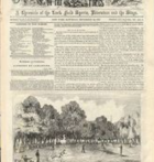
| Title | 1841 Douglas Map of Hoboken, Showing Elysian Fields and Fox Hill (page to be moved) |
|---|---|
| Source Image | |
| Category | LandscapeLandscape |
| Description | |
| Descriptors | 1841 Map of Hoboken1841 Map of Hoboken |
| Date | 1841 |
| Published Date | |
| Source | John Thorn |
| Location | Hoboken |
